Snowman
Trek I (to Sephu)
- 29 Nights 30 Days
- Western & Central Bhutan
Duration: 29
Nights 30 Days (Trek- 25 days)
High Season: March, April, May,
September, October & November
Low Season: January, February, June, July,
August & December
| Jan | Feb | Mar | Apr | May | Jun | July | Aug | Sept | Oct | Nov | Dec |
Max. Elevation:
5,320m
Highest Camp: 5,050m
Standard: Hard
Best Seasons: Mid June to Mid October
Start: Drugyal Dzong (Paro)
Finish: Sephu (Trongsa)
Summary: The Snowman Trek is an extension of the beautiful Laya Gasa Trek, and leads from Laya into high altitudes of the Bhutanese Himalayas. It takes tough and enduring trekkers into the Lunana region and further on to Mount Gangkhar Puensum and Bumthang or down to Sephu in Trongsa district, depending on which route you choose. This route, Snowman Trek I is the one leading to Sephu, while Snowman II is the one leading to Bumthang. The Snowman trek leads through the most remote areas up to very high altitudes. Trekkers have to camp in altitudes above 5,000 metres above sea level more than once and depending on the seasonal temperatures, the camps are sometimes on snow.
The Lonely Planet describes the Snowman Trek as one of the most difficult treks of the world. Many groups that attempt this tough trek do not actually finish it due to problems with the high altitude or snow blocked passes. Therefore, the best time for the Snowman Trek- unlike the other high altitude treks of Bhutan- is in summer time. Still, those who make it will remember this trek as outstanding and beautiful and maybe as the most rewarding trek of their life.
One should be reasonably physically fit to enjoy the majestic mountain views, endure thin air, serenity & the wilderness of the landscape while on the trek. Altitude sickness can be a problem.
Itinerary Outline:
Day 1: Arrive Paro
Day 2: Day hike to Tiger’s Nest Monastery
Day 3: Drugyal Dzong - Sharna Zampa (Trek Begins)
Day 4: Sharna Zampa- Thangthangkha
Day 5: Thangthangkha - Jangothang
Day 6: Jangothang Halt.
Day 7: Jangothang - Lingshi
Day 8: Lingshi - Chebisa
Day 9: Chebisa - Shomuthang
Day 10: Shomuthang - Robluthang
Day 11: Robluthang - Limithang
Day 12: Limithang - Laya
Day 13: Rest/Acclimatisation day in Laya
Day 14: Laya - Rhoduphu
Day 15: Rhodophu - Narethang
Day 16: Narethang - Tarina
Day 17: Tarina - Woche
Day 18: Woche-Lhedi
Day 19: Lhedi-Thanza
Day 20: Rest day at Thanza.
Day 21: Thanza - Danji
Day 22: Danji - Tshochena
Day 23: Tshochena - Jichu Dramo
Day 24: Jichu Dramo - Chukarpo
Day 25: Chukarpo - Thampe Tsho
Day 26: Thampe Tsho - Maurothang
Day 27: Maurothang - Sephu - (Trek Ends) - Drive to Punakha
Day 28: Drive Punakha to Thimphu
Day 29: Drive Thimphu to Paro
Day 30: Depart Paro for home
Detailed Itinerary:
Day 1: Arrive Paro
Upon being received at the airport by our representative, check into Hotel. Later, we visit Tag Dzong, built in the 17th century as a watch tower for Paro Rinpung Dzong. This Dzong was later converted into the National Museum in 1967 and is filled with antique thangkhas (Buddhist paintings on cloth), textiles, antique weapons and armour. Also visit the Rinpung Dzong, also built in the 17th century to defend the valley against Tibetan invaders. It is now used as an administrative centre and home for the monastic community. Stroll around town. Overnight at Hotel.
Day 2: Day hike to Tiger’s Nest Monastery
In the morning, you will visit the Drugyal Dzong (Bhutan Victory Fort), which was built in 1646 to commemorate Bhutan's victory over the Tibetans in the 1600s. On a clear day you can see the captivating view of Mount Jhomolhari, Bhutan's second-highest mountain at 7,314 metres. Then you will hike to Taktsang (the Tiger's Nest) Monastery, which is Bhutan's most famous monastery. It is perched precariously on the edge of a steep cliff 900 metres above the Paro Valley floor. Visit the Monastery and hike back to Paro. In the evening visit a traditional farm house which offers opportunity to mingle with local people and their lifestyle. If you wish, you can have a traditional Bhutanese dinner with buttermilk, 'Dao' in Dzongkha. Overnight at the hotel in Paro.
Day 3: Drugyal Dzong - Sharna
Zampa (Trek Begins)
(Distance 17 km, four to five hours, 360 m ascent, 80 m descent,
camp altitude 2,850 m)
Drive up to Drugyal Dzong (2,580 m) where the road ends and the trek begins. With a gradual climb the trail follows the Paro Chhu passing beautiful meadows, paddy fields and impressive farm houses. After about four hours you will reach the army post at Gunitsawa village. At the army checkpost your trek permit (provided by us) will be checked and endorsed. The campsite is on the opposite side of the river, not far from Gunitsawa.
Day 4: Sharna Zampa- Thangthangkha
(Distance 22 km, seven to eight hours, 770 m ascent, 10 m descent,
camp altitude 3,610 m)
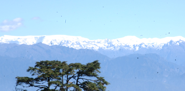
On this long day, the trail continues with lots of small ups and downs. After going uphill through the river valley, you enter the Jigme Dorji National Park. The valley finally narrows gradually to a mere path which descends to a meadow where a camp will be set up. From here, weather permitting, you will have the first great view of Mount Jhomolhari (above).
Day 5: Thangthangkha - Jangothang
(Distance 19 km, five to six hours, 480 m ascent, camp altitude
4,080 m)
If you did not see Mount Jhomolhari last evening, you will have a great chance to get a great view this early morning. This morning the trek continues up the Paro Chhu (Paro River) valley which widens into patches of alpine meadow and scanty growths of forest. Cross an army outpost along the way and enjoy a spectacular view of high mountain ridges and snow-capped peaks. Yaks and the herders' homes become a regular feature of the landscape. Passing the villages of Soe, Takethang and Dangochang is another asset on this day. Reaching Jangothang, one of the most beautiful campsites of the Himalayas, you will again have a spectacular view of Mount Jhomolhari.
Day 6: Jangothang Halt
The day in Jangothang provides plenty of possibilities for day hikes with great views on lakes and snow capped mountains such as Jhomolhari and Jichu Drakey. There are good chances to spot some blue sheep on the upper slopes of the valley. Jangothang is a perfect environment for your acclimatisation. Trek up to Tosoh or hike around the area. There are good short hiking trails in three directions. Jhomolhari and its subsidiary mountain chains lie directly west, Jichu Drakey to the north and a number of unclimbed peaks to the east.
Day 7: Jangothang - Lingshi
(Distance 18 km, six to seven hours, 840 m ascent, 870 m descent,
camp altitude 4,010 m)
After 15 minutes from the camp the trail climbs rapidly for about half an hour and then becomes a gradual ascend to the Nyilila pass at 4,870 m. While on the climb enjoy the surroundings. You might see herds of blue sheep grazing on the slopes of the mountains. From the pass you will have spectacular views of Mt. Jhomolhari, Jichu Drakey and Tsheringang, all of them rising above 7,000 m. On the way down to the camp you will pass by some of the yak herders’ tent, made from yak wool, where the herders take shelter while on the move to various pastures for their yaks. As you come down into the Lingshi basin, you get a wonderful view of Lingshi Dzong on a clear day. Tsheringang and its glaciers rise up at the north end of the valley. The campsite is next to a stone hut you reach just before Lingshi Dzong.
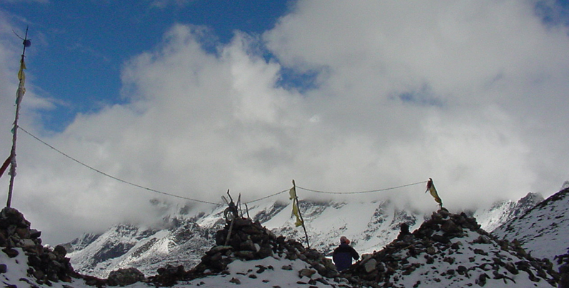
View along the route...
Day 8: Lingshi - Chebisa
(Distance 10 km, five to six hours, 280 m ascent, 410 m descent,
camp altitude 3,880 m)
Today is the shortest walking day and
you can really take it easy. Shortly after starting you will reach a chorten
below Lingshi Dzong. Here, you have the choice of staying on the main
trail or taking a diversion up to Lingshi Dzong (4,220 m), which sits
right atop a ridge. Besides a very special atmosphere of mystic silence
Lingshi Dzong provides a great view over the valley. After Lingshi Dzong
you will be passing the villages of Lingshi and Goyul. In Goyul, the stone
houses are clustered together to a small compact village that is unusual
in Bhutan where village houses are normally scattered. On reaching the
campsite at Chebisa with a beautiful waterfall behind the village, you
will have plenty of time to visit the village if you feel up to it.
Day 9: Chebisa - Shomuthang
(Distance 17 km, six to seven hours, 890 m ascent, 540 m descent,
camp altitude 4,220 m)
You walk through a wide pastureland
towards Gobu La ('La' means pass). On the way, you will see a few people
herding yaks. There is also a great chance to spot large herds of blue
sheep above the trail. After crossing the Gobu La (4,410 m) you descend
to the valley, then climb again a little bit, and descend again to Shakshepasa
(3,980 m) where incidentally, a helipad has been established. Climbing
from here you will finally reach the campsite at Shomuthang above a river,
which is a tributary of the Nochhu River.
Day 10: Shomuthang - Robluthang
(Distance 18 km, six to seven hours, 700 m ascent, 760 m descent,
camp altitude 4,160 m)
As the walk is a little strenuous it
is advisable to start early. Climbing up the valley to view Kang Bum (6,526
m) and some edelweiss. After two hours of climbing you will reach Jhari
La (4,750 m), from where you catch the first sight of Sinchu La, the pass
you will have to cross the day after. The big snow peak in the north is
Gangchhenta 6,840 m, better known as the Great Tiger Mountain. If the
weather is clear, Tserim Kang and the top of Jhomolhari will be visible.
The camp by the river is called Tsheri Jathang. Herds of Takin, the Bhutanese
National Animal, migrate to this valley in summer and remain for about
four months. The valley has been declared a Takin sanctuary. Climb up
a little bit and you will reach the campsite at Robluthang in a rocky
meadow.
Day 11: Robluthang - Limithang
(Distance 19 km, six to seven hours, 850 m ascent, 870 m descent,
camp altitude 4,140 m)
After crossing Sinchu La (5,005 m) -
the last and highest pass on the trek in case you don’t intend to
continue the Snowman trek from Laya onwards - you descend to a little
stone house where a few Laya women - dressed in typical Laya costume with
long pointed bamboo hats on their head - live and offer their weaving
products. Right behind the stone house you will see an impressive terminal
moraine (a mass of rocks and sediment deposited by a glacier marking the
farthest advance of the glacier) and a glacial lake at the foot of the
valley. You can see classic examples of the lateral moraines where the
glacier has pushed rocks up both sides of the valley. Below the moraine,
you cross the Kango Chhu and soon reach the Limithang campsite. The peak
of Gangchhenta towers over the campsite even though it’s quite a
distance away.
Day 12: Limithang - Laya
(Distance 10 km, four to five hours, 60 m ascent, 340 m descent,
camp altitude 3,840 m)
Today you walk all the way downhill along a narrow winding river valley. After a long time you again trek partly through deep forests. The trail leads you to the west side of Laya village. From the west of the village you will view Gangchhenta again and catch a glimpse of Masagang. In the village centre is a community school and a basic health unit with telephone connection. The campsite is below the school.
Day 13: Rest/Acclimatisation day in Laya
If you have trekked from Drugyal Dzong
you should spend a day recuperating from the trek to Laya and preparing
yourself for the rest of this challenging but spectacular trek. If you
have started from Tashithang/Damji (Punakha) you should also walk up to
Laya to acclimatise, and not just stay at the trail junction to Lunana.
It’s worthwhile to spend one day in Laya just for the great views
from Laya and its extraordinary inhabitants.
Day 14: Laya - Rhoduphu
(Distance 19 km, six to eight hours, 1,030 m ascent, 750 m descent, camp
altitude 4,160 m)
From Laya we descend to an army camp
and continue following the river till the turn off point to Rhoduphu.
After lunch the climb continues through rhododendron bushes till you reach
the camp at Roduphu just next to the Rhodu Chhu.
Day 15: Rhodophu - Narethang
(Distance 17 km, five to six hours, 740 m ascent, camp altitude
4,900 m)
After following the river for about
half an hour you will have a steady climb to a high open valley at 4,600
m and then further up to Tsomo La (4,900 m). Tsomo La offers a superb
view of Lunana, Mount Jhomolhari and Jichu Drakey, and the Tibetan border.
The route then crosses a flat, barren plateau at about 5,000 m. The campsite
at Narethang is towered by the peak of Gangla Karchung (6,395 m).
Day 16: Narethang - Tarina
(Distance 18 km, five to six hours, 270 m ascent, 1,200 m descent,
camp altitude 3,970 m)
From the camp you will climb for about
an hour to Gangla Karchung La (5,120 m). The view from the pass is breathtaking
and the whole range of mountains including Jekangphu Gang (7,100 m), Tsenda
Kang and Teri Gang (7,300 m) can be seen. The pass descends along a large
moraine. Again one has great views- a massive glacier descends from Teri
Kang to a deep turquoise lake at its foot. Up here a glacial lake burst
through its dam in the early 1960s, causing widespread damage and partially
destroying Punakha Dzong. Finally, it is a very long descent through thick
rhododendron to Tarina valley, where you will find several good campsites
along the Tang Chhu.
Day 17: Tarina - Woche
(Distance 17 km, six to seven hours, 270 m ascent, 330 m descent,
camp altitude 3,910 m)
The walk leads down through conifer
forests following the upper ridges of the Pho Chhu passing some impressive
waterfalls. The trail then climbs over a ridge and drops to Woche, a settlement
of a few houses, the first village in the Lunana region.
Day 18: Woche-Lhedi
(Distance 17 km, six to seven hours, 980 m ascent, 1,190 m descent,
camp altitude 3,700 m)
The trek starts through juniper and
fir forests, and further ahead, through rhododendron bushes. Climb up
to Keche La pass (4,650 m) where one can have the great view of surrounding
mountains again. After the pass, descend to the riverside walking through
a village with a stunning view of Table Mountain and others. Follow up
the river till Lhedi Village. Lhedi has a basic health unit, a school
and a wireless telephone connection.
Day 19: Lhedi-Thanza
(Distance 17 km, seven to eight hours, 450 m ascent, camp altitude
4,150 m)
In clear weather, you will have great
views of Table Mountain (7,100 m). Around lunchtime you will pass the
small village of Chozo (4,090 m) which has a Dzong still in use. Reaching
Thanza again you will have a great view of Table Mountain which forms
a 3,000 m high wall of snow and ice behind the village. Although there
are possibilities to camp directly at Thanza, most groups prefer to camp
in Thoencha.
Day 20: Rest day at Thanza
In Thanza walk around and experience
some village life or climb up the ridge for fascinating views of lakes
and mountains. But as it takes time to arrange new yaks (the yaks from
Laya will not go further than Thanza) you might have to spend one day
at Thanza anyway.
Day 21: Thanza - Danji
(Distance 8 km, three to four hours, 80 m ascent, camp altitude
4,230 m)
From Thoencha, the trail climbs up to a large boulder from where you will have excellent views of Thanza, Toencha and Choso village and the surrounding mountains. After a few hours of relatively flat and easy walking, you will reach a yak meadow with some yak herders’ huts. An excellent campsite with a great chance to spot some blue sheep on the hills above. A trail junction near the campsite will give you the choice between the route up to Gangkhar Puensum base camp, and further on to Bumthang or to Sephu (Trongsa). Both routes are described in this website- this route 'Snowman Trek I' is the Sephu one. The Bumthang one is Snowman II.
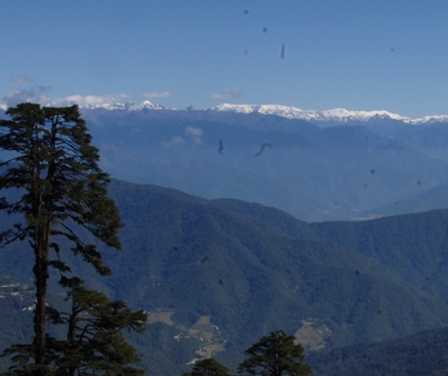
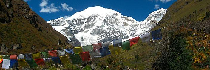
Trekking along the Himalayas...
Day 22: Danji - Tshochena
(Distance 12 km, five to six hours, 980 m ascent, 240 m descent,
camp altitude 4,970 m)
Having chosen this route to Sephu, the
trek crosses the creek and after a long climb, you will reach Jaze La
(5,150 m) with spectacular panoramic mountain views. The path then descends
between snow covered peaks and a couple of small lakes to the campsite
near the shore of Tshochena Lake.
Day 23: Tshochena - Jichu Dramo
(Distance 14 km, four to five hours, 230 m ascent, 150 m descent,
camp altitude 5,050 m)
You follow the bank of the blue green
lake before arriving at a ridge at 5,100 m, where there is another spectacular
view in all directions. After going up and down over small hills to reach
a glacial lake, the route descends first before climbing again up the
next pass, the Loju La (5,140 m). Finally after crossing a small saddle
(5,100 m) you will enter a wide glacial valley from where the trail descends
gradually to the campsite at Jichu Dramo.
Day 24: Jichu Dramo - Chukarpo
(Distance 18 km, five to six hours, 320 m ascent, 730 m descent,
camp altitude 4,600 m)
Right after leaving the camp you will
climb through a moraine to Rinchen Zoe La (5,320 m). Spectacular mountain
scenery with Gangkhar Puensum amongst the impressive mountains is the
reward for climbing the highest pass on this trek route. Rinchen Zoe Peak
(5,650 m) towers above the pass the west. Descending from the pass, the
route leads into a wide valley with several lakes and goes steeply down
along a moraine to the Thamphe Chhu. Here the vegetation begins to thicken
again and you will see the first real trees since Lhedi. After a couple
of hours you reach the campsite at Chukarpo.
Day 25: Chukarpo - Thampe Tsho
(Distance 18 km, five to six hours, 400 m ascent, 700 m descent,
camp altitude 4,300 m)
The descent continues along the river
till you reach the yak herders' huts at Gala Pang Chhu (4010 m). From
here the trail climbs steeply towards Thampe Tsho, a beautiful clear turquoise
lake, with the campsite next to it.
Day 26: Thampe Tsho - Maurothang
(Distance 14 km, five hours, 330 m ascent, 1020 m descent, camp
altitude 3,610 m)
From the lake you climb steeply to the
last pass on your trek, the Thampe La (4,600 m) with a good chance to
spot some blue sheep on the way. Then the path descends to the sacred
lake Om Tsho. Passing a waterfall you will reach another, smaller lake
100 m below to descend steeply to the Nikka Chhu. The path finally leads
through mixed forest to large clearing on the banks of the river with
a few yak herder huts- Maurothang.
Day 27: Maurothang - Sephu - Drive to Punakha
(Distance 18 km, five to six hours, 990 m descent)
On the last day of this extraordinary trek your porters will have to change from yaks to horses as the yaks will not be willing to go further down. The path follows the Nikka Chhu to reach a large grassy area overlooking the road and the village of Sephu. You finally reach the road at the Nikka Chhu Bridge at Sephu where you will find several stores (mainly selling bamboo products) and small restaurants. Overnight in Punakha at a very comfortable hotel.
Day 28: Drive Punakha to Thimphu
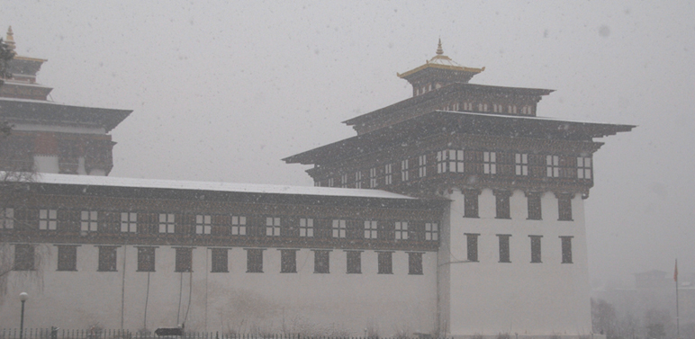
Tashichhodzong snowed in. The first day of snow in Thimphu is
normally declared a Government holiday. This winter, 21 January 2013 (Monday)
was the holiday declared for the 19 January (Saturday) snow.
We will have time in the morning to see Punakha Dzong (the second of Bhutan's Dzongs to be built and the Dzong featuring on our welcome page) which for many years served as the seat of Government. The Dzong was first built in 1637 and is still one of the largest in Bhutan. It is the winter residence of the Je Khenpo, the Chief Abbot of Bhutan. We will drive to Thimphu in the morning (about 2 hours) and have the afternoon to visit Thimphu, the capital of Bhutan. We will visit the Tashichodzong (above), built as the symbol of the capital and then explore the shops along Norzin Lam, Thimphu's main street.
Day 29: Drive Thimphu to Paro
The morning is free to do some more sightseeing or shopping around Thimphu. In the afternoon we take a 2 hour drive through the lovely central foothills to Paro where we will overnight in a comfortable hotel.
Day 30: Depart Paro for home
Morning we will have time for one last walk through Paro town before saying farewell and leaving Bhutan behind, taking your memories with you...
Note: These trekking itineraries have been designed based on past experiences of visitors to Bhutan and what they experienced about various trek routes. They show the actual duration of the trek only. They can be combined with other cultural tours or treks. The treks are such that you can gain the maximum out of this experience without exhausting you. The treks may depend on seasons. However, these readymade itineraries may not be convenient for some visitors. That is why we would be very happy to, together with you, design a new itinerary to fit all criteria and interests as desired by you. Please write to us with your special interests and/or requirements at bhutanrebirth@gmail.com.
| |
BACK TO TREKS MAIN PAGE |