Laya Gasa Trek
- 20 Nights 21 Days
- Western Bhutan
Duration: 20
Nights 21 Days (Trek- 14 days)
High Season: March, April, May,
September, October & November
Low Season: January, February, June, July,
August & December
| Jan | Feb | Mar | Apr | May | Jun | July | Aug | Sept | Oct | Nov | Dec |
Max. Elevation: 5,005
m
Highest Camp: 4,220 m
Standard: Medium to hard
Best Seasons: April to June & Mid September to Mid
November
Start: Drugyal Dzong (Paro)
Finish: Tashithang (Punakha)
Laya Gasa Trek Summary:
The first part of the Laya Gasa Trek goes along the same route as Jhomolhari Trek I right till Lingshi. Besides the unforgettable views of Mount Jhomolhari, the trek offers spectacular views on Jichu Drakey and Gangchhenta (Great Tiger Mountain). Between Jangothang and Laya the trail hardly goes below 4,000 metres above sea level and one has good opportunities to spot the Blue Sheep or even the National Animal of Bhutan- the Takin. Some beautiful Bhutanese mountain villages, the unique culture and appearance of the Layaps (people of Laya district) and finally a day of relaxation at the Gasa hot springs add to an extremely rewarding trekking experience. All in all, the Laya Gasa Trek is considered to be the most beautiful trek of Bhutan, beaten only by the tough Snowman Trek.One should be reasonably physically fit to enjoy the majestic mountain views, endure thin air, serenity & the wilderness of the landscape while on the trek.
Itinerary Outline:
Day 1: Arrive Paro
Day 2: Paro Acclimatisation Hike
Day 3: Drugyal Dzong - Sharna Zampa (Trek Begins)
Day 4: Sharna Zampa- Thangthangkha
Day 5: Thangthangkha - Jangothang
Day 6: Jangothang Halt.
Day 7: Jangothang - Lingshi
Day 8: Lingshi - Chebisa
Day 9: Chebisa - Shomuthang
Day 10: Shomuthang - Robluthang
Day 11: Robluthang - Limithang
Day 12: Limithang - Laya
Day 13: Laya - Koina
Day 14: Koina - Gasa
Day 15: A Day at Gasa Tsachhu
Day 16: Gasa Tsachu - Tashithang - Punakha (Trek ends)
Day 17: Punakha with Excursion to Wangdue
Day 18: Punakha - Thimphu
Day 19: Sightseeing in Thimphu
Day 20: Thimphu - Paro
Day 20: Excursion to Chelela Pass
Day 21: Paro Depart
Detailed Itinerary:
Day 1: Arrive Paro
Upon arrival in Paro, you will be greeted by our representative and transferred to your hotel. After lunch in the restaurant, you can visit the Paro Rinpung Dzong. It was built in 1646 and now houses government offices and religious institutions, as do all the Dzongs (fortresses) currently. You'll cross a traditional wooden bridge on the way to the Dzong. Afterward you will visit Kyichu Lhakhang, the oldest temple in the country. From there you will be taken to the Drugyal Dzong (Bhutan Victory Fort), which was built in 1646 to commemorate Bhutan’s victory over Tibetan invaders during the 1600s. On a clear day you can see Mount Jhomolhari, Bhutan’s second-highest mountain at 7,329 metres, from the village below the Dzong. In the evening you can stroll through the Paro market and town. Overnight at Paro.
Day 2: Paro Acclimatisation Hike
After breakfast, full day excursion to Taktsang or the “Tiger’s Nest” perched precariously on a cliff 900 m above the floor of the Paro valley. It is the most famous monastery in Bhutan. It is said that Guru Rinpoche flew to the site of the Monastery on the back of a Tigress and meditated here for three months. Lunch will be served in the Cafeteria. Return to Paro in the evening. Overnight at the Hotel in Paro.
Day 3: Drugyal Dzong - Sharna
Zampa (Trek Begins)
(Distance 17 km, four to five hours, 360 m ascent, 80 m descent,
camp altitude 2,850 m)
Drive up to Drugyal Dzong (2,580 m) where the road ends and the trek begins. With a gradual climb the trail follows the Paro Chhu passing beautiful meadows, paddy fields and impressive farm houses. After about four hours you will reach the army post at Gunitsawa village. At the army checkpost your trek permit (provided by us) will be checked and endorsed. The campsite is on the opposite side of the river, not far from Gunitsawa.
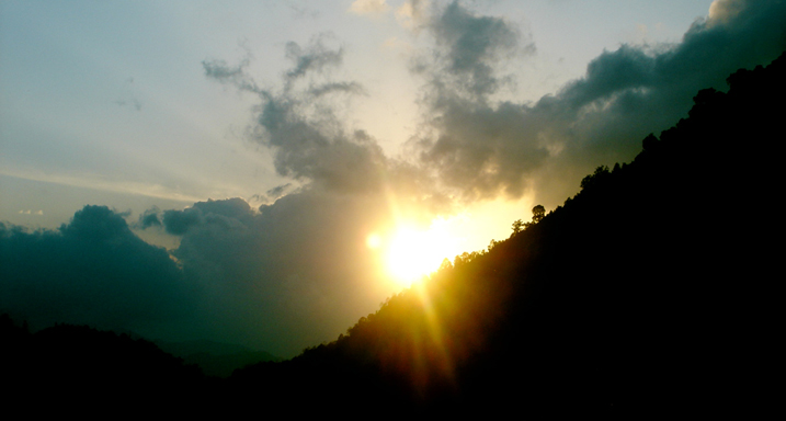 The day ends along with the sun... along the trail.
Day 4: Sharna Zampa - Thangthangkha
(Distance 22 km, seven to eight hours, 770 m ascent, 10 m descent,
camp altitude 3,610 m)
On this long day, the trail continues with lots of small ups and downs. After going uphill through the river valley you enter the Jigme Dorji National Park. The valley finally narrows gradually to a small path which descends to a meadow where a camp will be set up. From here, if weather permits, you will have the first great view of Mount Jhomolhari.
Day 5: Thangthangkha - Jangothang
(Distance 19 km, five to six hours, 480 m ascent, camp altitude
4,080 m)
If you did not see Mount Jhomolhari last evening, you will have a great chance to get a great view this early morning. This morning the trek continues up the Paro Chhu valley which widens into patches of alpine meadow and scanty growths of forests. Cross an army outpost along the way and enjoy a spectacular view of high mountain ridges and snow-capped peaks. Yaks and the herders' homes become a regular feature of the landscape. Passing the villages of Soe, Takethang and Dangochang is another asset on this day. Reaching Jangothang, one of the most beautiful campsites of the Himalayas, you will again have a spectacular view of Mount Jhomolhari.
Day 6: Jangothang Halt
The day in Jangothang provides plenty of possibilities for day hikes with great views on lakes and snow capped mountains such as Jhomolhari and Jichu Drakey. There are good chances to spot some blue sheep on the upper slopes of the valley. Jangothang is a perfect environment for your acclimatisation. Trek up to Tosoh or hike around the area. There are good short hiking trails in three directions. Jhomolhari and its subsidiary mountain chains lie directly west, Jichu Drakey to the north and a number of unclimbed peaks to the east.
 Day
7: Jangothang-Lingshi
Day
7: Jangothang-Lingshi
(Distance 18 km, six to seven hours, 840 m ascent, 870 m descent,
camp altitude 4,010 m)
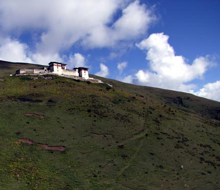
About 15 minutes from the camp the trail climbs rapidly for about half an hour and then becomes a gradual ascent to the Nyilila pass at 4,870 m. While on the climb enjoy the surroundings. You might see herds of blue sheep grazing on the slopes of the mountains. From the pass you will have spectacular views of Mt. Jhomolhari, Jichu Drakey and Tsherimgang, all of them rising above 7,000 m. On the way down to the camp you will pass by some of the yak herders’ tent, made from yak wool, where the herders take shelter while on the move to various pastures for their yaks. As you come down into the Lingshi basin, you get a wonderful view of Lingshi Dzong (left) on a clear day. Tserimgang and its glaciers rise up at the north end of the valley. The campsite is next to a stone hut you reach just before Lingshi Dzong.
Day 8: Lingshi - Chebisa
(Distance 10 km, five to six hours, 280 m ascent, 410 m descent,
camp altitude 3,880 m)
Today is the shortest walking day and
you can really take it easy. Shortly after starting you will reach a chorten
below Lingshi Dzong. Here, you have the choice of staying on the main
trail or taking a diversion up to the Lingshi Dzong (4,220 m), which sits
right atop a ridge. Besides a very special atmosphere of mystic silence
Lingshi Dzong provides a great view over the valley. After Lingshi Dzong
you will be passing the villages of Lingshi and Goyul. In Goyul, the stone
houses are clustered together to a small compact village that is unusual
in Bhutan where village houses are normally scattered. On reaching the
campsite at Chebisa with a beautiful waterfall behind the village, you
will have plenty of time to visit the village if you feel up to it.
Day 9: Chebisa - Shomuthang
(Distance 17 km, six to seven hours, 890 m ascent, 540 m descent,
camp altitude 4,220 m)
You walk through a wide pastureland
towards Gobu La (pass). On the way, you will see a few people herding
yaks. There is also a great chance to spot large herds of blue sheep above
the trail. After crossing the Gobu La (4,410 m), you descend to the valley,
then climb again a little bit, and descend again to Shakshepasa (3,980
m) where a helipad has been established. Climbing from here you will finally
reach the campsite at Shomuthang, above a river which is a tributary of
the Nochhu River.
Day 10: Shomuthang - Robluthang
(Distance 18 km, six to seven hours, 700 m ascent, 760 m descent,
camp altitude 4,160 m)
As the walk is a little strenuous, it
is advisable to start early. Climbing up the valley to view Kang Bum (6,526
m) and some edelweiss. After two hours of climbing you will reach Jhari
La (4,750 m) from where you catch the first sight of Sinchu La, the pass
you will have to cross the day after. The big snow peak in the north is
Gangchhenta 6,840 m, better known as the Great Tiger Mountain. If weather
is clear, Tserim Kang and the top of Jhomolhari will be visible. The camp
by the river is called Tsheri Jathang. Herds of Takin, the Bhutanese National
Animal, migrate to this valley in the summer and remain for about four
months. The valley has been declared a Takin sanctuary. Climb up a little
bit and you will reach the campsite at Robluthang in a rocky meadow.
 Day
11: Robluthang - Limithang
Day
11: Robluthang - Limithang
(Distance 19 km, six to seven hours, 850 m ascent, 870 m descent,
camp altitude 4,140 m)
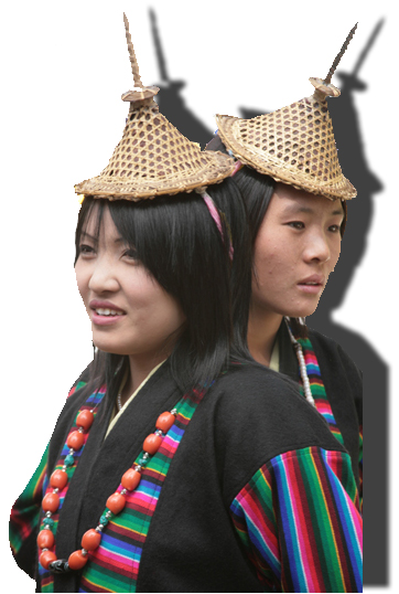
After crossing Sinchu La (5,005 m) -
the last and highest pass on the trek in case you do not intend to continue
the Snowman trek from Laya onwards - you descend to a little stone house
where a few Laya women - dressed in typical Laya costume with long
pointed bamboo hats on their head (see right) - live and offer
their weaving products. Right behind the stone house you will see an impressive
terminal moraine and a glacial lake at the foot of the valley. You can
see classic examples of the lateral moraines where the glacier has pushed
rocks up both sides of the valley. Below the moraine, you cross the Kango
Chhu and soon reach the Limithang campsite. The peak of Gangchhenta towers
over the campsite even though it’s quite a distance away.
Day 12: Limithang - Laya
(Distance 10 km, four to five hours, 60 m ascent, 340 m descent,
camp altitude 3,840 m)
Today, you walk all the way downhill
along a narrow winding river valley. After a long time, you trek partly
through deep forest again . The trail leads you to the west side of Laya
village. From the west of the village you will view Gangchhenta again
and catch a glimpse of Masagang. In the village centre is a community
school and a basic health unit with telephone connection. The campsite
is below the school.
Day 13: Laya - Koina
(Distance 19 km, six to seven hours, 260 m ascent, 1,070 m descent,
camp altitude 3,050 m)
The trail winds up and down along the
river valley of the Mo Chhu avoiding natural obstacles and affording breathtaking
views of the crashing river, feeder streams and waterfalls. Lots of ups
and downs will lead you to Kohi Lapcha at 3,300 m. The trek then drops
down to the large stream of Koina Chhu, where you will find the campsite
of Koina.
Day 14: Koina - Gasa
(Distance 14 km, six to seven hours, 740 m ascent, 1,500 m descent,
camp altitude at Gasa Tsachhu (Hot Springs) 2,240 m)
Today you will have your last major climb of the Laya Gasa Trek. You will cross the Bari La pass at 3,740 m, after which the trail is all the way down till you reach Gasa village (2,770 m), where you will find the first restaurants since starting from Drugyal Dzong. There also is a campsite close to Gasa Dzong (You will have to decide if you want to stay in Gasa village or descend for another one hour to the Gasa Tsachhu (Hot Springs) and relax in the natural, thermal hot springs. The Gasa Tsachhu is one of the most popular hot springs in Bhutan).
Day 15: A Day at Gasa Tsachhu
After a late breakfast, trek to Gasa Tsachu. After lunch relax in the Hot Springs. The Gasa Tsachhu is one of the most popular hot springs in Bhutan. Camp at Gasa Tsachhu. You can either laze around in the hot springs or take a pack lunch and climb about two hours to visit Gasa village and the Dzong.
Day 16: Gasa Tsachhu - Tashithang
- Punakha (Trek ends)
Distance 18 km, 5-6 hours
After a short climb, the trail winds through rolling hills and passes through the pine and oak forests, villages and wheat fields. You will also see a beautiful view of Gasa Dzong glued to the valley wall seeming to float in space. Arrive at Damji. Your car will be waiting here to take you to Punakha. You will drive through the high agricultural benches above the Mo Chhu (Chhu means water, in this case River) into a lush semi-tropical gorge filled with banana trees, creepers and various tropical vegetation till Tashithang. Continue driving to Punakha. Overnight at the Hotel in Punakha.
Day 17: Punakha with excursion to Wangdue
After breakfast drive for half-hour to Wangdue. Wangdue town which is
a typical small Bhutanese town, with a bustling market and well stocked
shops. Visit Wangdue Dzong, the 17th Century Monument, unfortunately razed
by fire on the afternoon of 24 June 2012. It sits atop a high ridge between
the Puna Tsang Chhu and the Dang Chhu. The place is also known for its
fine bamboo work, slate and stone carvings. Also visit Rinchengang village
on the opposite side of the river, which is a unique cluster of houses
made up of red mud. The people of this village are of Indian origin, who
originally were brought into Bhutan as construction workers of the Dzong
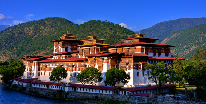
(fortress). In the evening drive back to Punakha (Punakha Dzong
seen above at Dusk). Overnight at the Hotel in Punakha.
Day 18: Punakha - Thimphu
Set out for Thimphu with a stop at Dochu La for tea. Visit the new Druk Wangyal Monastery, which is the only one of its kind in the country with elaborate paintings depicting the lineage of the present Monarchy and their visionary works. Continue drive to Thimphu and check into your hotel on arrival. Overnight at the Hotel In Thimphu.
Day 19: Sightseeing in Thimphu
Visit the Memorial Chorten (a huge stupa) built in memory of the Third King who reigned from 1952-1972. Visit the National Library where ancient manuscripts are preserved. Visit the Wood Craft and Painting school where traditional arts and crafts are still kept alive. Visit the Handicrafts Emporium where Bhutanese textiles and other arts and crafts are displayed and can be purchased. Visit Semtokha Dzong. This is one of the oldest fortresses in Bhutan. It was built in 1629 AD. Visit Tashichhodzong, the Main Secretariat Building. This massive structure houses part of the government Ministries, the Office of the King and the Throne Room. It also houses the State Monastic Body, living quarters of the Chief Abbot and the senior monks. Overnight at the Hotel in Thimphu.
Day 20: Thimphu - Paro
In the morning you can hike to Tango Monastery, which was built by the
"Divine Madman" in the 15th century. It is a Centre of Study
for Monks and it affords a great view of Thimphu Valley. Drive back to
Thimphu and after lunch you will proceed to Paro. Overnight at the Hotel
in Paro.
Day 20: Excursion to Chelela Pass
After breakfast, you will drive to Haa Valley across Chela Pass 3810 m. On a clear day you will have views of Mount Jhomolhari and other mountains and valleys below the pass. Explore nearby mountains dotted with colourful prayer flags and blanketed with dwarf rhododendrons. If you want to be more adventurous you can hike further down the ridges to Kila Goemba Nunnery which is nestled in a craggy patch on the mountain site below the pass and perched precariously along the rock face. After a picnic lunch, you will drive to Paro. Overnight at the hotel in Paro.
Day 21: Paro Depart
Drive to Paro Airport. You will be seen off by our representative and it's Good Bye.....
Note: These trekking itineraries have been designed based on past experiences of visitors to Bhutan and what they experienced about various trek routes. They show the actual duration of the trek only. They can be combined with other cultural tours or treks. The treks are such that you can gain the maximum out of this experience without exhausting you. The treks may depend on seasons. However, these readymade itineraries may not be convenient for some visitors. That is why we would be very happy to, together with you, design a new itinerary to fit all criteria and interests as desired by you. Please write to us with your special interests and/or requirements at bhutanrebirth@gmail.com.
| |
BACK TO TREKS MAIN PAGE |