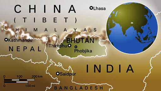
Where is Bhutan?
 The
Kingdom of Bhutan is a landlocked country high up in the Himalayas between
Tibet and India. From West to East it is about 300 kilometers (km) long
while it runs 150 km north to south. With an area of about 46,500 square
kilometers (roughly the size of Switzerland), its GPS Coordinates are
between longitudes 88045' and 92010' East and latitudes 26040' and 28015'
North. It is bounded by India in the South and South-West while in the
North and North-West the Tibetan autonomous region of China borders Bhutan.
The
Kingdom of Bhutan is a landlocked country high up in the Himalayas between
Tibet and India. From West to East it is about 300 kilometers (km) long
while it runs 150 km north to south. With an area of about 46,500 square
kilometers (roughly the size of Switzerland), its GPS Coordinates are
between longitudes 88045' and 92010' East and latitudes 26040' and 28015'
North. It is bounded by India in the South and South-West while in the
North and North-West the Tibetan autonomous region of China borders Bhutan.
Virtually the entire country is mountainous,
and ranges in elevation from 100 m along the Indian border to the 7,554
m Kulagangri peak on the Tibetan border. These two extremes frame a landscape
which stretches from sub-tropical to arctic like conditions.
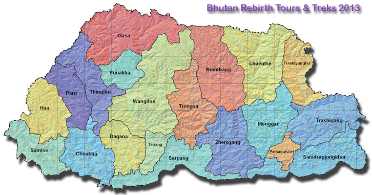
*. Bhutan is divided into 20 Districts, called Dzongkhags.
 Bhutan
Drainage/River system:
Bhutan
Drainage/River system:
Bhutan Kayaking and Rafting:
Safety:
• Bhutanese rafting and kayaking
guides are well trained and will do everything to ensure that you enjoy
the adventures minus the risks.
• The rivers of Bhutan were first graded for water sports in 1997
by the experienced duo Gerry Mofatt and Peter Knowles at the invitation
of the Royal Government, under the erstwhile Department of Tourism to
survey potential routes.
• They trained the first batch of Bhutanese river-guides and conducted
surveys.
• Since then, other rivers have been surveyed including the Punatsang
Chhu, Manas and Amo Chhu.
• TCB guidelines ensure that all operators use well maintained professional
equipment and a reasonable guide-client ratio
Bhutan Climate:
Spring lasts from mid-March to the beginning of June, with temperatures warming gradually to 27-29 degree centigrade by day and about 18 degree centigrade at night. However, cold spells are possible up until the end of April, with a chance of new snow on the mountains above the valleys. Strong, gusty winds start blowing almost everyday from noon to early evening . The first storms break and become more and more frequent with the approach of the monsoon which arrives in mid-June. The country receives abundant rain especially in the south, as it gets the full face of monsoon coming from the Bay of Bengal to which the mountains form a barrier. At the end of September, after the last of the big rains, autumn suddenly arrives and the sky gets clearer, a brisk breeze picks up and temperature starts falling towards freezing at night although bright sunshine continues to keep the days warm. Autumn is a magnificent season that lasts until mid-November and it is the best time to visit this fascinating mountain Kingdom.
![]()